Update on Brazos County Warming Centers

Brazos County warming centers are transitioning to standby operations. For more information and transportation options, call 2-1-1.

Brazos County warming centers are transitioning to standby operations.

The warming center at The Salvation Army is closed, but the Twin City Mission remains open and can provide overnight services for individuals and families. The VFW warming center is open tonight until 10, then is available as needed by dialing 2-1-1.

The American Red Cross, VFW, and United Way of the Brazos Valley partners are prepared to open the VFW warming center based on assessed needs. No pets are allowed.

For information about transportation options, call 2-1-1.

Warming Centers Available Thursday Through Sunday in Brazos County

Warming centers will be available Thursday through Sunday in Brazos County for those seeking relief from the expected freezing temperatures.

Warming centers will be available Thursday through Sunday in Brazos County for those seeking relief from the expected freezing temperatures.

The warming center at The Salvation Army is open Thursday from noon- 5 p.m. and Friday and Saturday from 9 a.m.-5 p.m. Water, snacks and charging stations are available. The Salvation Army is providing staff, volunteers and supplies.

A warming center at the VFW opens Thursday at 5 p.m. and will remain open until 11 a.m. on Sunday. Water, snacks and charging stations are available. Individuals and families are encouraged to bring personal supplies for overnight stays.

Pets are not allowed at either location. The Brazos Valley Food Bank is providing supplies for the VFW location, and the Twin City Mission is providing blankets.

For more information about the centers and transportation options, call 2-1-1.

Volunteer to Help

To volunteer at the VFW, click here. The Red Cross and Catholic Charities are coordinating shifts and training.

It’s Severe Weather Awareness Week: Make sure you know where your “safe places” are during these severe weather threats

As spring weather season begins, we want to remind you of where the safest places are to ride out these stormy possibilities:

Lightning

safe place - lightning

Lightning strikes the U.S. 25 million times a year, which sometimes results in death or permanent injury. You are safest indoors, or inside a hard-topped enclosed vehicle. Stay Weather-Ready and learn more about lightning safety at weather.gov/safety/lightning.

Extreme Wind

safe place - high winds

During high winds, tree damage is expected, and loose objects can become airborne and dangerous. You are safest indoors, away from windows, in an interior room. Stay Weather-Ready and learn more about wind safety at weather.gov/safety/wind.

Flooding

safe place - flooding

During a flood, water levels and flow speed can quickly change. You are safest by staying indoors, or seeking higher ground if shelter isn’t available. If you’re stuck outside when a flash flood occurs, do not attempt to cross flood waters by vehicle or on foot. Learn more about flood safety at weather.gov/safety/flood.

Tornadoes

safe place - tornadoes

Tornadoes can be extremely dangerous. Safe places include storm shelters and basements — but if not available, an interior room without windows can also be protective. If you receive a tornado warning, take shelter immediately! Learn more about tornado safety at: weather.gov/safety/tornado.

Assistance in the Wake of the Winter Storm

Disaster assistance may be available to Brazos County residents adversely affected by last week’s winter storm. Residents who suffered snow and ice damage can apply for federal funds at DisasterAssistance.gov, or by calling 1-800-621-3362.

Anyone with insurance is asked to first contact their insurance company and then FEMA, as insurance claim information is needed in determining eligibility for federal assistance. Those without insurance can go directly to DisasterAssistance.gov to begin the process of filing an application. (FEMA is unable to reimburse lost food due to power outages, but volunteer organizations may be able to help if food assistance is needed. Call 211 for more.) FEMA has also partnered with the U.S. Small Business Administration (SBA) to offer low-interest disaster loans. More information is available at www.fema.gov/disaster/4586.

After submitting an application, FEMA will notify each person either via tradition mail service or email.

To get a better picture of the damage in each county, the State of Texas is asking residents to take part in a survey, either by going to https://arcg.is/uOrOb or using the QR Code:

qr code assistance winter storm

Laura Expected to Be Category 4 Hurricane Before Making Landfall Along TX-LA Border

Hurricane Laura is rapidly strengthening and is expected to be an extremely dangerous Category 4 hurricane before making landfall along the Texas-Louisiana border on Wednesday night.

The threats to areas around Sabine Pass and the Texas-Louisiana border region are significant from this storm.

See the 10 a.m. update from the National Hurricane Center

At this time, Brazos County does not appear to be in significant danger from the effects of the storm. Forecasts show we may get some thunderstorms, perhaps 1 inch of rainfall and some gusty winds, but the main threats are to the east of us.

Still, it’s a good idea to keep an eye on the latest weather reports and be aware as this powerful storm hits the gulf coast.

Hurricane Laura Pushes Toward Upper Texas Coast; Shelters Opened in San Antonio, Austin, DFW

local storm warnings

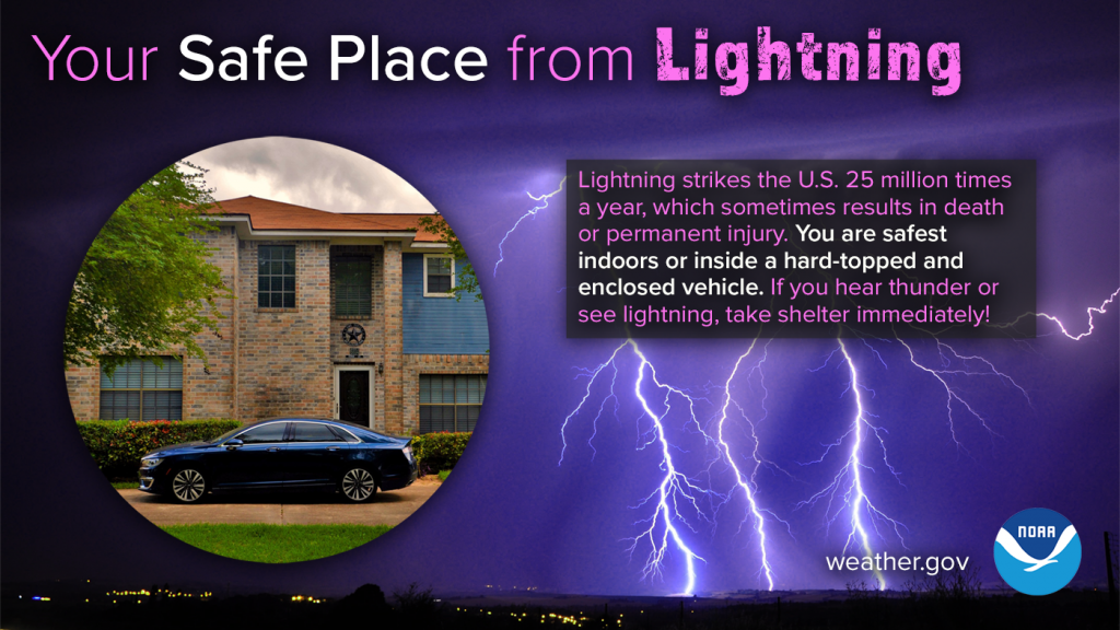
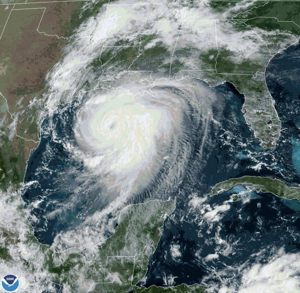
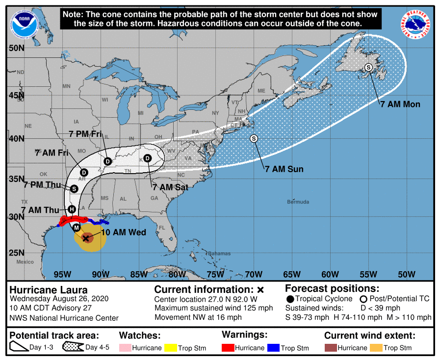
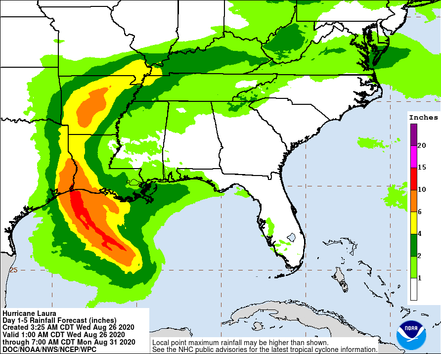
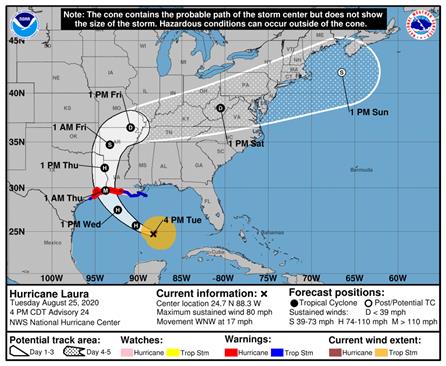
Hurricane Laura continued its march toward the upper Texas and Louisiana coasts on Tuesday amid predictions that the storm will intensify to a Category 3 hurricane by the time it makes landfall on Wednesday night or Thursday morning.

As of 4:30 p.m., Brazos County had not been included in official hurricane or tropical storm warnings, but that doesn’t mean we’re necessarily in the clear. Storms like this can change direction quickly, and the storm itself is moving at a rapid pace. That means stronger winds will be felt further inland than with typical tropical systems.

The latest prediction is for Laura to make landfall along the Texas-Louisiana border, but a slight shift to the west could put us right in its path. Now is the time to stay vigilant and monitor local weather updates and alerts about this potentially major hurricane.

hurricane laura path

Shelters Opened in San Antonio, Austin, Dallas area

Shelters have been opened in three major metropolitan areas to take in evacuees fleeing Hurricane Laura. There are no general public shelters open in Brazos County at this time.

Here’s a list of Evacuee Reception Centers:

San Antonio
254 Gembler Road
San Antonio, TX 78219
(Open at 3 p.m. on Tuesday, Aug. 25)

Austin
Circuit of the Americas
9201 Circuit of the Americas Boulevard
Austin, TX 78617
(Open at 4 p.m. on Tuesday, Aug. 25)

Dallas / Fort-Worth
Mesquite Reception Center
15515 E. IH-20
Mesquite, TX 75181
(Opened at 7 p.m. on Tuesday, Aug. 25)

Ellis County / North Texas
Knights of Columbus Hall
850 S IH-45
Ennis, TX 75119
(Open at 7 p.m. on Tuesday, Aug. 25)

Extreme Heat Blankets Brazos Valley

heat temperatures map

Here’s the latest from the National Weather Service in Houston/Galveston:

Our relentless stretch of dangerous heat continues. A heat advisory is again in place from 11 am to 8 pm today, with several hours of triple digit heat index values. Peak forecast heat index will again be up to around 110°.

The heat wave carries on, with another day of dangerous heat ahead. Much of the area is beginning the morning with temperatures around 80° and a heat index in the 80s, but things will escalate rapidly after sunrise this morning.

Look for the heat index to exceed 100° area-wide by 10 or 11 am, and will not drop below 100° again until late this evening. The maximum heat index will come in the late afternoon (around 4 pm or so) with a peak in the vicinity of 110°.

Extended Outlook

Unseasonable heat will stay with us through the week. Fortunately, yesterday and today will likely signal the peak intensity of this hot stretch. Unfortunately, improvement this week will be very slow, and heat levels will remain dangerous for several more days. Heat advisories may be needed for more days this week.

Take Precautions

  • Limit any time outdoors, especially during the afternoon
  • Check your backseat for any pets or children
  • Check in with your neighbors, especially the elderly
  • Drink plenty of water to stay hydrated
  • Wear sunscreen and light clothing

Hurricane season begins June 1. Don’t be unprepared.

It’s hard to believe, but June 1 and the start of hurricane season are right around the corner.

The National Weather Service has a terrific guide to everything you need to know about the 2020 season, from forecasts and hurricane names to safety recommendations and even tips for dealing with your insurance company if you have storm damage.